 HOME
HOME
EFFIS – The European Forest Fire Information System has its origins in a 1998 European Commission (EC) Joint Research Centre (JRC) initiative intended to develop advanced means of determining forest fire danger, and mapping burnt areas on a European scale. It has since developed into an open-source information portal with applications available to experts and public alike that can have positive effects at policy, operational, and tactical levels. Declan Daly provides a rundown on the system.
With the Forest Fires Experts Group also meeting for the first time in 1998 (established from personnel within member states by the
Directorate General of the Environment (DG ENV) and JRC to advise on the development of methods for fire assessment), the road was paved for
EFFIS to become operational two years later in 2000. Since that time, the system has undergone frequent improvements, and became part of the
EU's Copernicus Programme, the EU Space Programme's Earth Observation component, which employs both space and surface- based systems to
deliver an overall and accessible picture of the Earth to provide information on the environment, manage climate change and improve
security. EFFIS, very clearly, is a component that takes onboard all three parameters of the overall Copernicus Programme.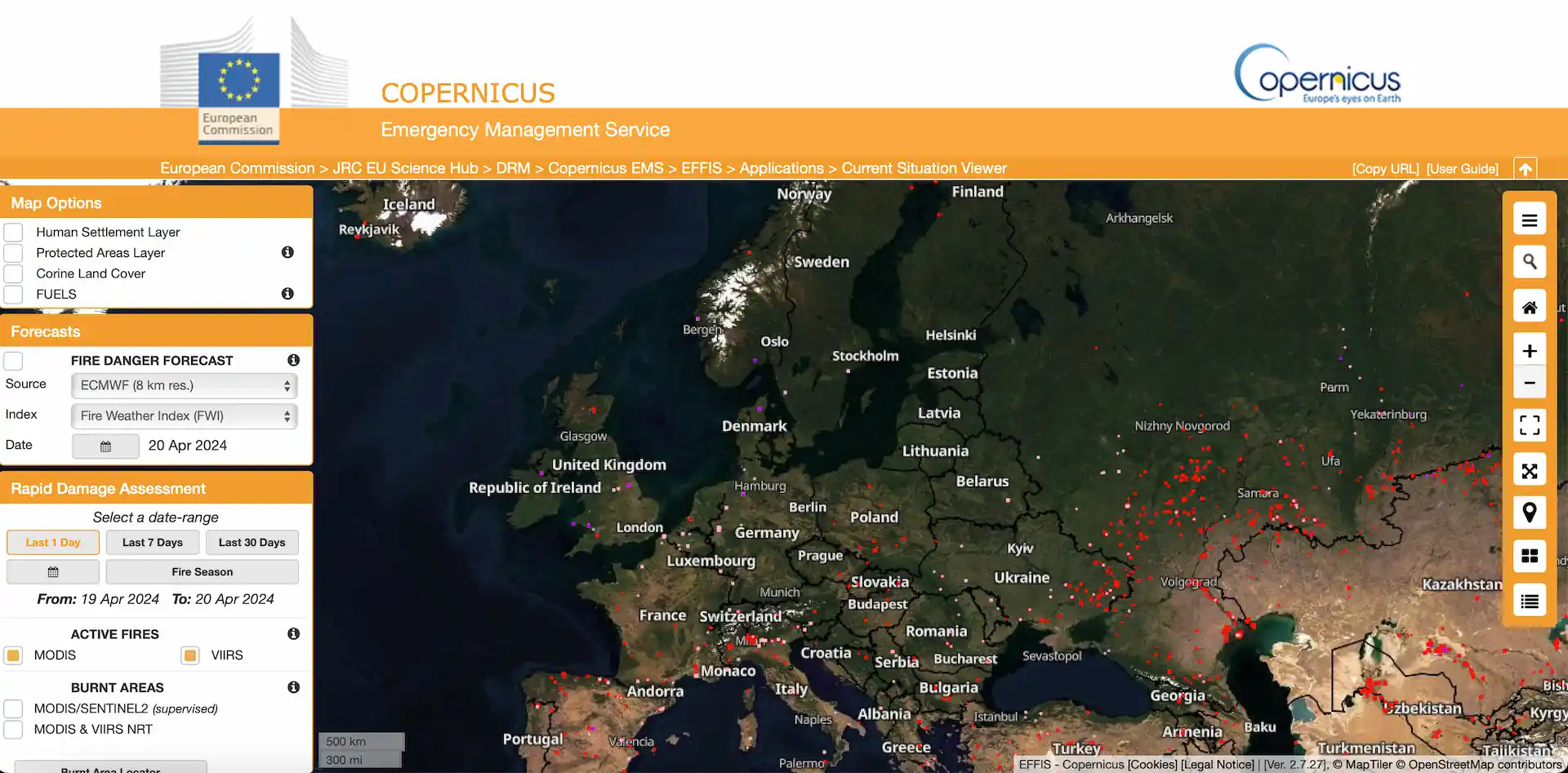
Policy Level – Driving Evidence Based Decision Making
What then does EFFIS do for its users in practise? Accessible online by anyone, EFFIS makes a vast amount of data, trends, and forecasts available in one place. This is a valuable asset for those whose position requires them to make evidence based decisions on the distribution of funds and assets, both at the national level and at an EU level. There are specific features which work well to support users at different decision-making strata. In terms of setting up policy makers to assign funding and assets correctly, data is presented through a Statistics Portal which, at a glance, provides data on fire activity both at a member state level and also encompassing averages that affect the whole of the EU, with trends shown dating back to 2006. This data is presented in an easy to understand manner covering current year activity against a backdrop of max/min averages from the last fifteen years.
Critically, the information is contextualised by annual reports from member states. These put some meat on the bones of the raw data and can help explain ‘blips’ in the numbers so that they are not misinterpreted as an early start to a fire season, or evidence of acute weather effects as a result of climate change. For example, the Irish report for 2022 was able to explain away a spike in fires in February as being a result of legislative measures brought in as part of an EU wide curlew preservation effort – farmers were carrying out controlled burns before the nesting season. As a side note, these burns can be quite extensive. Having flown passed one that extended over more than a kilometre long still burning at night in the driving rain, and with the smell of accelerant still detectable at over a thousand feet, ‘controlled’ deserves the inverted commas it sometimes gets in regard to these fires! The reports from member states EFFIS wide similarly highlight that most of the fires encountered are caused by human activity, the weather conditions just facilitate them.
The reports also provide data on the assets used to combat fires, and their levels of success. This in turn provides an evidence base that allows for targeted improvements to be made in the respective countries and across all member states.


Although labelled as a European project, partner nations extend beyond the periphery of the EU and include Algeria, Israel and Lebanon – this is significant as the trend monitoring carried out using EFFIS, and taking information from the Copernicus Program as a whole, allows a medium and long term view of the effects of climate change to be developed as they relate to forest fires. As climate change is considered to be a driver of population movement and a potential generator of conflict, creating such a view allows policy makers to be prepared to meet the humanitarian needs of large movements of people towards Europe as well as the borders of partner nations. Acute weather phenomenon such as fires, if the global fire season increases in intensity and duration, may well come to a point where the sheer weight of migration could threaten to overwhelm locally available assets and lead to a greater humanitarian disaster. If the forecasting and current situation tools of EFFIS allow for a degree of preparation to avoid this, this is an obvious win in humanitarian, economic and security terms.
Operational Level – Pre-emptive Planning for the Coming Season
Policies, however, are always executed at the tactical level. Countering fires in support of national and European policies is a task for
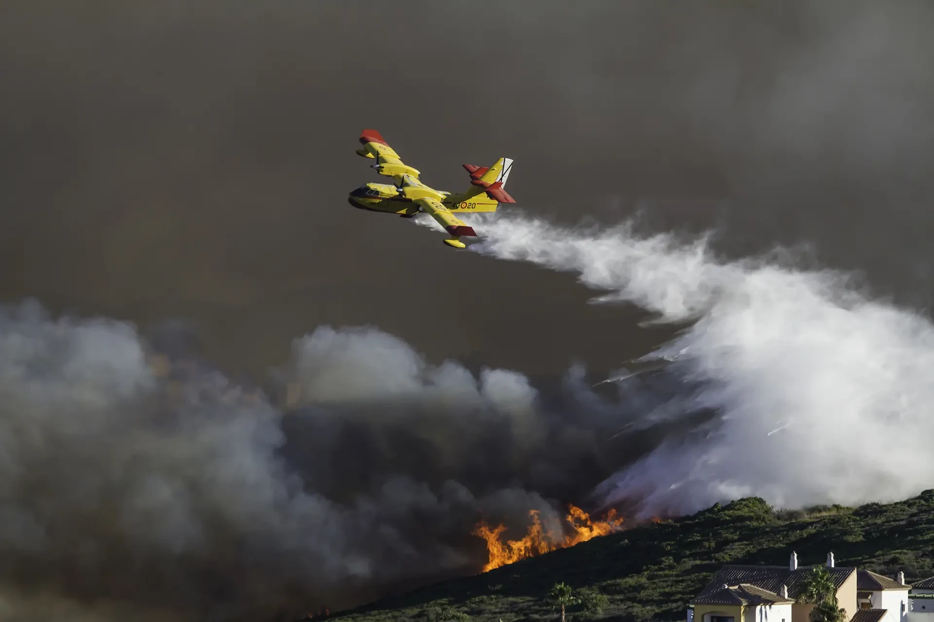
rescEU – a fully EU funded reserve of European capacities equipped to respond to wide range of disasters. It has an expanding fleet of
firefighting aircraft for the mission. Currently numbering some twenty four fixed wing and four rotary wing assets, this is already double
that available in previous years. Recognising that even this fleet is not large enough, twelve Canadair 515 aircraft have also been ordered
which will be EU funded, but owned and crewed by Croatia, France, Greece, Italy, Portugal, and Spain. Assets operated by rescEU are
available not just to EU states but to other countries outside Europe who request their assistance. It was under this scheme that six
firefighting aircraft were deployed to Lebanon in 2019, four of which were from rescEU (two each from Italy and Greece).

Even when this expanded fleet comes online, when one takes into account the area it will be responsible for, it is likely that demand will still outstrip supply in specific instances during the fire season. Like any other resource, these aircraft must be rationed and being able to plan ahead to some degree will streamline operations and minimise time lost moving between countries which are affected by fires. At this operational level, EFFIS once again supplies tools that can assist planners before a fire season even starts. The systems Long Term Seasonal Forecast Apps provides both Monthly and Seasonal temperature and rainfall anomaly apps which forecast the difference between the average temperature and rainfall for an area and that which is actually expected to occur. The information driving these maps is based on the European Centre for Medium Range Forecast (ECMWF) Monthly Forecast System (MFS).
Using these apps before the annual fire season begins will give rescEU planners an opportunity to identify that years' likely areas of operation ahead of time, and to make suitable arrangements in each locality regarding basing, fuelling and diplomatic clearances where necessary. It would also give an opportunity to identify useful water sources in each country that are capable of accepting aircraft of the size operated by rescEU – for example, not every lake is suitable for use by a CL515 and knowing what is, and importantly, what isn't, available to each aircraft type before arriving in country saves precious time. Saving time in this way not only increases the chances of successfully dealing with a fire, but also increase the opportunity to redeploy the same assets multiple times in the same season to areas which have been pre-identified as being at risk using EFFIS forecasting. This helps to minimise the administrative and logistical burden that comes with any such move. It is important to point out that while the monthly and seasonal forecasts relate more to climate than actual weather, using them to build a database of likely operating bases is still time well spent if no fire occurs in that location in a given year.
Tactical Level – Fighting the Fire In Front of Me
At a more immediate tactical level, EFFIS offers a Current Situation viewer which can give both a local and continent wide view. This app allows users the ability to focus on ‘their own fire’ in a national or regional sense and get an overview of how it is behaving, what fuel sources are available to it and what areas have already been burned this season, along with displaying jurisdictional boundaries and built up areas. It also gives a forecast out to eight days, which coupled with a Fire Danger Forecast out to ten days (based on the Canadian Forest Fire Weather Index or FWI), allows those fire officers responsible for local distribution of assets a chance to plan, rotate units and call for extra assets with a reasonable degree of accuracy. Much of the information in the Current Situation viewer is based on satellite observation of the area, using Moderate Resolution Imaging Spectroradiometer( MODIS ) which detects areas of ground hotter than their surroundings with a resolution of 1Km, and Visible Infrared Imaging Radiometer Suite (VIIRS) which has a higher resolution at 375m, and is more useful at detecting fires overnight. Both satellite systems act in a complementary fashion to provide an accurate picture of emerging hot spots in near real time, without giving false alarms every time someone strikes a match.
Also giving a daily picture is the Fire News App. This is a neat little feature which is updated by a team member each day during the fire
season with geolocated news stories about forest fires. This recognises the fact that there will often be bystanders gathering information
with personal phones and cameras before emergency services are on scene, and that this information is often picked up and broadcast by
various parts of the media very quickly, thus providing a distributed means of gathering data to inform the decision making of local fire
fighters.

Future Fires - Planned Apps and Harnessing AI
A read through the history of EFFIS shows that it has been subject to constant upgrades and ongoing testing – to its credit it is using features such as the Seasonal Forecast on an experimental basis. In development at the moment are apps showing Post Fire Vegetation Recovery and Post Fire Soil Erosion Risk. Both identify areas where there may be an urgent post fire need to deploy resources to avoid loss of diversity of flora and fauna in the first case, and in the second to avoid further risk to life through loss of arable land and an increased potential for landslides. These fall somewhere between the policy level and the operational level in terms of utility.
One area that does not seem to be under review for now is also one that could bridge the gap between ‘near real time’ and ‘real time’. There is a growing number of AI based products coming to market which gather and combine information from every open source of information available, ranging from drones to sim cards in firefighters radios to accurately map the progress of a fire. Products such as Decamap are robust, including precise geolocation for panoramic views and drone-captured footage, which allows for a detailed understanding of the terrain and fire behaviour. Accurate geospatial labelling and AI based analysis further enables the rapid detection and classification of areas affected by fire, improves response times and operational effectiveness. Such fully integrated systems support seamless planning, tasking, monitoring, and coordination among multiple responding agencies, creating a Common Operational Picture, and facilitating a unified approach to wildfire management.

Creating an EFFIS portal to make this information available to all users seems like a logical next step in making the system an indispensable tool for everyone involved in the firefighting process. Working to integrate the growing diversity of AI products into EFFIS would transform the system from being a useful tool as it currently stands, to a gamechanger in how fires are dealt with in Europe and beyond and would set the standard for how information is shared across all levels in tackling future humanitarian and environmental disasters.